A Resiplan is….
A Resiplan is a Site plan but there's a rider to that. Let’s start by stating that there is no specific specification published for a Site plan like there is for a mobile phone for instance. And it's important to know this because not all Site Plans are equal. Resiplans are top of the tree when it comes to site plans - they are very comprehensive. And, because Resiplans use the latest hi tech tools, they are also very price competitive.
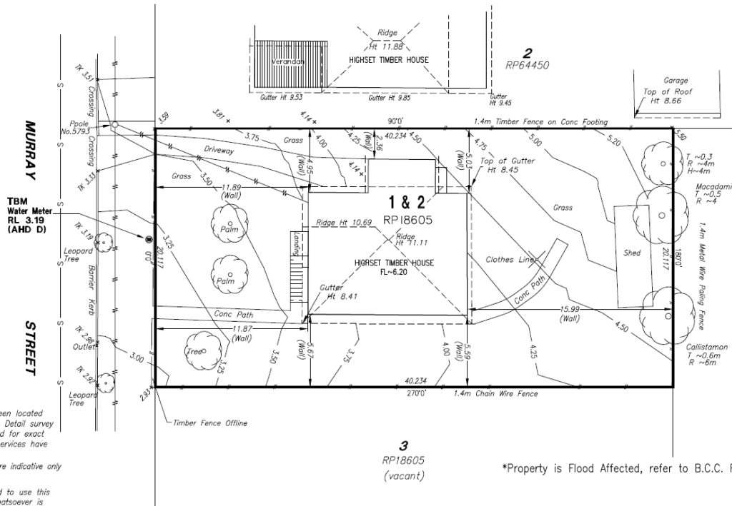
In its simplest form, a site plan can be a scale paper drawing that shows the full extent of your site for an existing or a proposed development for use by the variety of building professionals that constitute a project team. Site plans may be necessary for planning applications to local government authorities too. They are not to be confused with a soil survey. They are many and varied - there is no specific specification. As a result they do not always satisfy the task at hand. This can result in requests to revisit sites adding to additional cost and delays. Resiplans are a high quality site plan and are prepared with the most up-to-date equipment and technology. They are tailored to the task at hand and more.

Modern Technology
These days, with the adoption of building information modelling (BIM) using computer aided design software (CAD), Resiplans, using the latest information gathering tools and technology, now form an integral part of the “project information model”.
They can be prepared in 3D via laser scanning and other equipment resulting in what is known as a "point cloud". This has proved to be much quicker and more accurate than conventional survey measurement without any noticeable cost penalty. It is also recognized by most building industry professionals and all planning authorities
What’s more it provides building designers, project managers, town planners and other building industry professionals with much more information at a similar price point than they could have ever achieved before. This enables cost efficiencies through all stages of projects, especially if adopted early.
The use of helicopters and drones, especially for larger jobs, along with laser scanning has become a recognised method capturing the exact detail of topography and existing structures, often combined with site visits by appropriately equipped teams. In most cases, for smaller residential projects, site plans will be drawn up following an on-site investigation using up to the minute technological equipment to gather the current site data that is then used in a series of desk studies is married to existing government and local authority data garnered by way of multiple and sometimes costly searches and paid database access.

The Information needs to Vary
The information shown on a site plan will vary depending on the size and nature of the project, so it then becomes apparent that the greater the amount of information that is required the greater is the time and cost to gather that information and to prepare the plan. It's a necessary balance to ensure that the plan serves the purpose because skimping can lead to mistakes further down the track.

This is where Resiplans have perfected their service and differentiate themselves in provision of the exact requirements for the project at hand, using their intimate knowledge of the requirements for that project type. This way you only pay for what is needed, no less, no more, meaning expensive re-visits to site are not required also eliminating the time delays that would cause.
The types of information that can appear on site plans if required are, but not limited to, such things as follows: -
- A title block, giving the project name, drawing type, author, revision number, the scale being used etc.
- The property address.
- Directional orientation such as a compass or a north-pointing arrow.
- All key dimensions.
- Key materials used.
- Site boundaries and delineation of adjacent properties, including where necessary, adjoining, or adjacent structures, and possibly even surrounding streets.
- The location of the building or buildings in relation to their surroundings.
- Fencing, walls, and gates.
- Trees, tree types & size, and the main elements of the landscape.
- Parking areas with dimensions or capacities, and signage.
- Roads, footpaths, ramps, paved areas.
- Easements such as rights-of-way.
- Buildings to be demolished or removed.
- The extent of earthworks including, cut and fill, the provision of retaining walls.
- The layout of external services, including drainage, water, gas, electricity, telephone, manhole covers.
- The location of external lighting.
- The location of other miscellaneous external items such as bollards, fire hydrants, signage, litter bins, and so on.
So, as you can see, not only is a Resiplan a useful and important tool to facilitate the success of most building projects it’s also sensible to ensure that it contains the necessary information for that project. With Resiplans you can be assured of that.
Resiplans are an essential building block to ensure a successful project

